The first impression – Is the Yuneec H520 a good option for UAV mapping?
The Yuneec H520 is an imposing bird. Sporting striking colors (orange and black), and dimensions of 520 x 455 x 295 mm, the Yuneec H520 certainly makes quite an impression. Powered by six motors, the Yuneec H520 comes with a high voltage battery that gave us 23 minutes of flight time at an elevation of 6000 feet. When you are flying at low elevations, you can probably eke out 30 minutes of flight time.
Because the Yuneec H520 comes with six motors, you can fly more days in year. And because you have six motors (one each on each arm), you have greater redundancy. Losing a motor does not mean that you lose your bird (unlike the P 4 Pro).
The Yuneec comes with the E 90 camera – and this has the same sensor as the DJI Phantom 4 Pro. Also, till about six months back, Pix4D integration was not available on the Yuneec H520. And you had to use DataPilot, Yuneec’s own mapping application – which was significantly less capable compared to Pix4D.
Another advantages of using the Yuneec H520 is the complete absence of No Fly Zones (NFZ’s). So far so good. So, factoring in all of the above, we cannot really fault you with thinking that the Yuneec H520 is comparable to the DJI P 4 Pro when it comes to UAV mapping. Right? Not quite.
Drone U Chief Pilot, Paul Aitken decided to head out on the field to determine the best drone for UAV mapping, and arrive at some concrete data driven conclusions.
Methodology – Determining the Best Drone for UAV Mapping
In order to do an accurate UAV mapping comparison, we decided to map the exact same sections and generate the exact same images. All images were captured at 90 feet elevation with an identical flight path. We ran both the maps with the exact same systems, using the same templates and the same processing areas.
Initial Results
When we went out on the field, the first thing that struck us was the absence of autonomous flight modes on the Yuneec H520. Intelligent flight modes are built into the Phantom 4 Pro which makes it far easier to use.
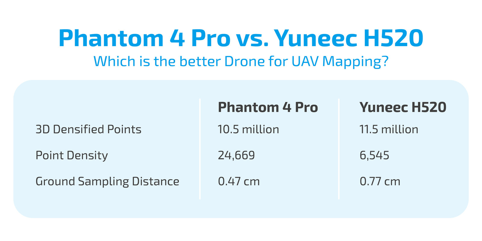
By the end of our test flights we ended up with 125 images on the Yuneec H520 and 122 images on the Phantom 4 Pro. When we processed these images, the results were starkly different. Let us look at the numbers –

GSD or ground sampling distance is “the distance between two consecutive pixel centers measured on the ground”. Lower the GSD, higher the resolution, and greater the amount of detail that you can capture. Your GSD is dependent on your focal length.
Rolling Shutter vs. Global Shutter – How your shutter type affects accuracy in UAV mapping
So, what could be the reason for these vastly different results? On digging deeper, we realized that this difference is because the Yuneec H520 comes with a ROLLING SHUTTER. Whereas, the P 4 Pro comes with a GLOBAL SHUTTER.
A rolling shutter exposes each pixel row of the sensor at different times. Whereas, a global shutter exposes all the pixels at one time. Now, when you are using a rolling shutter, the distance between the cameras sensor when reading the first pixel row and last pixel row varies. And, at normal drone speeds, this difference in distance can be as high as 1 m. This phenomenon, if not addressed can cause image distortion, and bring in inaccuracy in UAV mapping
In order to understand how a rolling shutter operates, let use a simple analogy. When you are scanning a paper, and you pull it out, what happens? You will notice that the image gets distorted. This is exactly what happens in a rolling shutter. Because the drone is moving and the camera is reading one pixel at a time, improper operations will result in distance variation, and hence, poor imagery. Surprisingly, even some high end drone cameras like X5 and X7 have rolling shutters.
Final Verdict – Phantom 4 Pro or Yuneec H520?
Once we realized this, we changed the settings in Pix4D to indicate that we were using a linear rolling shutter. Let us look at the numbers after doing so –

After making this change, using the Yuneec gave us more 3D densified points. But, point density was significantly lower compared to the DJI P 4 Pro. Ground sampling distance on the Yuneec H520 was also 0.73 cm compared to 0.47 cm for the DJI P 4 Pro. When we looked at our models in SketchFab, we also found color density for DJI Phantom 4 Pro to be far superior compared to Yuneec H520.
A greater point density, lower GSD and superior color density means that the DJI Phantom 4 Pro is your best bet for generating accurate UAV maps and models.
Check out our Medium page for more such content
Do not forget to subscribe and Listen to Ask Drone U, the #1 drone podcast
Connect with a vibrant drone community by becoming a Drone U member


Add Your Comment