Imagine you’re flying a drone over a city. The coordinates on your map tell you exactly where you are, but how do you describe your position in simpler terms? Are you talking about a fixed point on Earth, or are you comparing your location to something else around you?
When it comes to understanding location, two concepts dominate, relative location and absolute location. Both are essential for pilots, travelers, and even everyday navigation.
In this article, we’ll break down the differences between absolute vs. relative location, why these distinctions matter, and how they affect your journey.
First, let’s look at their roles in drone operations before understanding both terminologies.
Why Do Absolute and Relative Locations Matter?
When you’re piloting a drone, absolute location is a non-negotiable aspect of your flight operations.
Why? Because precise location data ensures you can:
- Avoid obstacles and know where you are in relation to airspace boundaries.
- Maintain a safe flight path, especially in urban environments.
- Perform accurate drone mapping and surveying.
However, relative location is important for understanding local context, such as flying near landmarks or guiding someone to your drone’s landing site.
Let’s understand them properly.
What Is Absolute Location?
Absolute location refers to a fixed point on Earth, often expressed in coordinates such as latitude and longitude. This method of describing location is exact, precise, and permanent—it doesn’t change no matter where you go.
Absolute location is crucial for navigation, mapping, and drone operations. It provides an exact reference, ensuring that systems relying on coordinates, such as flight controllers or air traffic control, can function without error.
Key Features of Absolute Location:
- Fixed Coordinates: Uses a global coordinate system like GPS (Global Positioning System).
- Unchanging: The location remains constant, regardless of surrounding landmarks.
- Highly Accurate: You can pinpoint a location to a high degree of accuracy, even down to the exact spot.
Example:
A drone’s GPS coordinates (e.g., 40.748817° N, 73.985428° W) are an absolute location. This tells you exactly where the drone is at a specific moment in time, with no room for interpretation.
What Is Relative Location?
Relative location describes a place in relation to another place. Rather than using coordinates, it compares the target location with nearby landmarks, cities, or natural features to give a sense of where it is.
The relative location is perfect for everyday communication. It’s useful when you need to explain your surroundings, like telling someone how to find your house or giving directions for drone operations in a specific area. However, it’s not as reliable for precision-based activities such as aviation.
Key Features of Relative Location:
- Descriptive: Describes a place relative to something else, like “next to the gas station” or “across from the park.”
- Dynamic: This location can change depending on where you are standing or how you reference it.
- Subject to Interpretation: People may describe the same location differently, depending on their perspective.
Example:
Let’s say you’re flying a drone near a city park. You might describe your drone’s location as “north of the city park,” which is a relative location based on the park’s position in the area.
Absolute vs. Relative Location Accuracy in Drone Operations
To make things clearer, let’s break it down in a simple table:
| Aspect | Absolute Accuracy | Relative Accuracy |
| Definition | Accuracy of coordinates in real-world positioning | Consistency of measurements within a survey |
| Example | Georeferenced maps aligning with GPS coordinates | Comparing images over time to detect changes |
| Use Case | GPS systems, aerial navigation, precise mapping | Directions, landmarks, local descriptions |
| Impact on Drones | Ensures location precision for autonomous flight | Improves internal consistency for change detection |
Now that we have a clear understanding of absolute vs. relative location, let’s explore how these locations play a significant role in drone operations.
How is Absolute Location Important for Drone Operations?
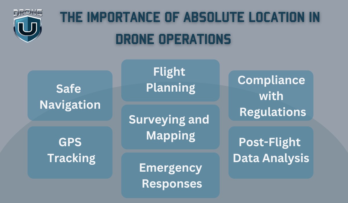
Absolute location is crucial for drone operations, particularly because it provides precision and accuracy. Drones rely on precise coordinates, such as latitude and longitude, to ensure safe, efficient, and accurate flights.
Here’s how absolute location plays a vital role in various aspects of drone operations:
1. Safe Navigation
For drones to fly safely, especially in complex environments like urban areas or near other aircraft, they need to know their exact location. The absolute location ensures that:
- Drones can avoid obstacles (e.g., buildings, trees, power lines) by providing accurate data about their current position.
- Flight paths are precise, ensuring that the drone follows its planned route without straying into restricted airspace or no-fly zones.
2. GPS Tracking
Drones use GPS systems to determine their absolute location during flights. This provides:
- Real-time tracking of the drone’s position, which is essential for operators to monitor and control the drone remotely.
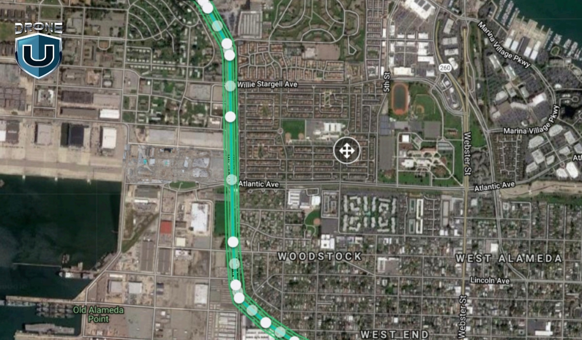
- Autonomous navigation for drones programmed to follow specific paths, such as in mapping or surveying missions. The drone will rely on its absolute location to navigate from point A to point B accurately.
3. Flight Planning
Before a drone flight, operators plan the flight route, often using maps or specialized software that relies on absolute location data. This ensures:
- Optimal routing, especially when flying long distances or over large areas for surveying or inspection.
- Compliance with regulations, as certain zones, like airports or military areas, have restricted airspace. Absolute location data ensures the drone avoids these zones by staying within permissible boundaries.
4. Surveying and Mapping
Drones are widely used in industries like construction, agriculture, and real estate to create accurate maps or conduct land surveys. Here, absolute location is vital because:
- Coordinates from GPS allow drones to capture precise imagery or data at exact locations.
- This data can later be used to create highly accurate 3D models or maps, useful for planning and decision-making in fields like urban development or agriculture.
5. Emergency Responses
During search-and-rescue missions or emergency operations, drones with absolute location capabilities can:
- Quickly pinpoint the location of the incident, whether it’s a wildfire, missing person, or accident site.
- Share real-time GPS coordinates with emergency responders to ensure fast and efficient coordination.
6. Compliance with Regulations
In many countries, including the United States, FAA regulations require drone operators to adhere to specific rules regarding where drones can fly. Absolute location helps operators:
- Stay within legal limits by ensuring drones don’t fly into restricted or no-fly zones.
- Maintain a clear record of their flight paths and locations for regulatory purposes, especially when operating in controlled airspace.
7. Post-Flight Data Analysis
After a flight, absolute location data can be used for:
- Analyzing flight performance, like the accuracy of the drone’s path or how well it adhered to its planned route.
- Verifying mission success, especially in tasks like surveying, mapping, or inspecting where precise location data is essential for the outcome.
How is Relative Location Used in Daily Life?
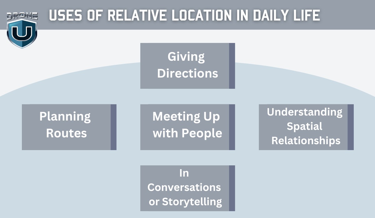
Relative location is incredibly useful in daily life because it helps us navigate and understand our surroundings without needing precise coordinates or maps.
It’s the way we describe places in terms of proximity to other known landmarks or places.
Here are a few practical ways relative location is used daily:
1. Giving Directions
When people ask for directions, they usually use relative location to explain where something is. For example:
- “The coffee shop is next to the post office.”
- “My house is across from the grocery store.”
This method of giving directions doesn’t rely on exact coordinates. Instead, it’s all about landmarks and familiar points of reference.
2. Planning Routes
When driving or walking, we often plan our routes using relative location. For instance:
- “Turn left at the traffic light and continue until you see the big red building on your right.”
- “My friend lives two blocks away, next to the park.”
This helps us navigate through areas we already know without needing detailed maps or GPS.
3. Meeting Up with People
When making plans to meet someone, relative location is key:
- “I’ll meet you in front of the library.”
- “Let’s gather at the park near the fountain.”
These descriptions give a good sense of where to meet without requiring exact coordinates. We rely on shared knowledge of common places.
4. Understanding Spatial Relationships
Relative location is also used to understand the spatial arrangement of things around us. For example, when you’re at a shopping mall:
- “The food court is on the second floor, across from the electronics store.”
- “The restroom is in the back, next to the exit.”
This kind of description makes it easy to find things based on their position relative to each other.
5. In Conversations or Storytelling
In daily conversations, we often use relative location to describe where things happened or to explain a situation:
- “I was at the park when I saw the fire truck coming from the hospital nearby.”
- “He lives right by the beach, near the old lighthouse.”
This helps others visualize and understand locations without needing specific addresses or coordinates.
Conclusion
In the world of navigation, absolute vs. relative location both serve their purposes. While absolute location provides precision and is vital for reliable navigation and drone operations, relative location helps with orientation and provides context in everyday conversations.
Understanding the distinction between these two can make your drone flights more efficient and safe, particularly when you need to communicate with ground teams or plan your next move.
FAQs
1. How to Find Exact Location by Using Longitude and Latitude?
Absolute location relies on longitude and latitude to pinpoint a precise spot on the Earth’s surface. So, how do you use these coordinates to find an exact location?
Let’s break it down!
1. Understand the Coordinate System
To find a location using longitude and latitude, you first need to understand the coordinate system:
- Latitude: Measures the distance north or south of the Equator. It ranges from 0° at the Equator to 90° at the poles.
- Longitude: Measures the distance east or west of the Prime Meridian, which runs through Greenwich, England. Longitude ranges from 0° at the Prime Meridian to 180° east and west.
Together, these coordinates provide a precise, unchanging location anywhere on Earth.
2. Use an Online Map or GPS Tool
One of the easiest ways to find the exact location is through Google Maps or a GPS tool. Here’s how:
A. Google Maps
- Open Google Maps.
- In the search bar, enter the latitude and longitude. For example, 40.748817, -73.985428.
- Hit Enter, and Google Maps will zoom directly to that exact location.
B. GPS Devices or Apps
If you’re using a GPS device or smartphone:
- Enter the coordinates into your device.
- The GPS will show you the exact spot based on those coordinates.
3. Plotting Coordinates on a Map
If you prefer a more manual approach, you can plot the coordinates on a map:
- Latitude tells you whether the location is north or south of the Equator.
- Longitude indicates whether the place is east or west of the Prime Meridian. Using a physical map, you can trace the coordinates to pinpoint the exact location.
4. Using GPS for Drones
For drone operators, GPS coordinates are critical. By inputting the absolute location into the drone’s GPS, you ensure your drone stays on track and avoids obstacles. This allows you to navigate to an exact spot with precision.
2. What Tools Are Used to Find an Absolute Location?
GPS, Mapping software, and Compass are mainly used for accurate and reliable absolute location data for navigation, mapping, and drone operations.
3. Can the Same Place be Described Using Both Absolute and Relative Location?
Yes, the same place can be described using both absolute and relative location, but the two provide different types of information.
- Absolute Location: This is the precise, fixed point on Earth given by latitude and longitude coordinates. For example, the Eiffel Tower is located at 48.8584° N, 2.2945° E. This gives an exact, unchanging position.
- Relative Location: This describes a place in relation to another known location. For example, the Eiffel Tower is located in Paris, France, near the Seine River, or west of the Louvre Museum.
Both descriptions give you a clear understanding of where the place is, but absolute vs. relative location highlights the difference. The absolute location gives exact coordinates, while the relative location provides context and landmarks for easier understanding.


 Podcast Question?
Add Your Comment