The rise of unmanned aerial vehicles (UAVs), has transformed many industries. Agriculture, however, might be one of the areas where drones are proving most indispensable. This is a relatively recent development in the history of drones in agriculture. These high-tech flying machines are giving American farmers a whole new toolbox for success. With drones, they can monitor crops, manage fields, and optimize their operations with incredible efficiency and precision.
Agriculture has always been a cornerstone of the American economy and way of life. With its vast fertile lands and rich agricultural history, the U.S. has a long tradition of adopting cutting-edge technologies to boost farm productivity and sustainability. The widespread use of drones in agriculture is a testament to this commitment to innovation and adaptation.
Equipped with advanced sensors and cameras, drones can capture high-resolution images and data from the sky. This information would be difficult or even impossible to get using traditional methods on the ground.
Farmers can use drone data for a variety of tasks, such as creating detailed field maps, assessing crop health, monitoring livestock, and detecting pest infestations. Drones have become a game-changer for American agriculture.
The story of drones in U.S. agriculture showcases the industry’s ability to embrace change. From the early days of research and development to today’s widespread commercial applications, the journey has been filled with challenges, breakthroughs, and a constant drive to improve farming practices.
This article will delve into this fascinating history of drones in agriculture, exploring how drones went from experimental projects to mainstream tools on American farms.
A History of Drones and their Agricultural Evolution
Drones have become a game-changer in agriculture. But their story in the fields is a recent chapter. This exploration of the history of drones in agriculture will trace the rise of drones from early tools to the high-tech helpers they are today, showing how they are revolutionizing the way we do farming.
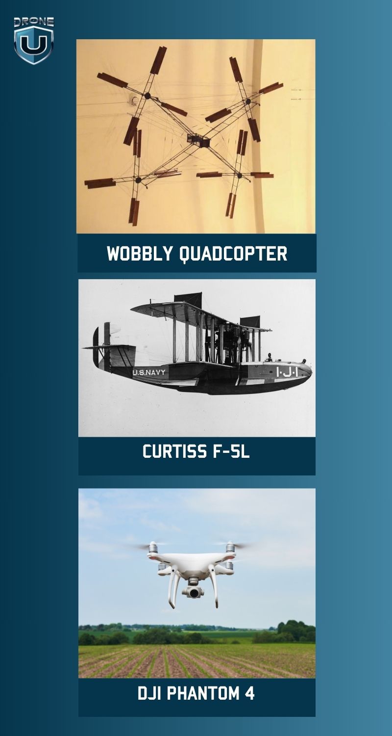
1907: The Birth of the Wobbly Quadcopter
Inventor brothers Jacques and Louis Bréguet, along with Nobel laureate (though somewhat controversial) Professor Charles Richet, created the world’s first quadcopter. However, this early design had some major limitations. It couldn’t be steered, required four people just to hold it steady, and on its very first flight, it only managed to lift a measly two feet off the ground. Despite these challenges, it pioneered the quadcopter design that we recognize today.
2006: Drones Take Flight for Business
Recognizing the potential of drones beyond military and recreational use, the FAA issued the first-ever commercial drone permits in 2006. This meant companies and professionals could now use drones for various business ventures, something previously restricted. While initial applications were slow, the number of permits issued quickly grew, demonstrating the increasing demand for commercial drone technology.
2013: Drones Get Smarter with DJI’s Phantom
In 2013, DJI entered the consumer drone market with the launch of the Phantom. This user-friendly drone was a hit with customers due to its ease of use compared to other options on the market. The Phantom’s success led to internal disagreements at DJI, but the company continued its growth trajectory.
In 2015, DJI built on the Phantom’s success with the release of the Phantom 3. This iteration included a built-in live-streaming camera, which further boosted its popularity.
A year later, DJI released the Phantom 4, showcasing their continued innovation in the consumer drone space.
This game-changer introduced intelligent features like computer vision and machine learning. This allowed the drone to avoid obstacles and even intelligently track and photograph people, animals, or objects, rather than simply following a pre-programmed GPS route. The Phantom 4 marked a significant milestone for both enterprise and the consumer drone market as a whole.
Early History of Drones in Agriculture
The way farmers use aerial technology has come a long way. marking a significant chapter in the history of drones in agriculture.
It all started with basic surveying and mapping techniques, but today it’s about cutting-edge precision farming.
The story begins in the early 1900s when airplanes and satellites first took to the skies to capture bird’s-eye views of farmland. This innovative approach allowed farmers to:
- Monitor crop growth from a whole new perspective.
- Spot potential problems like pests or irrigation issues before they become major threats.
- Survey vast areas of land with incredible efficiency and accuracy, saving them time and resources.
These aerial images weren’t just for looking. They became the foundation for creating detailed maps, digital elevation models (fancy 3D maps of the land), and powerful analytical tools.
This information revolutionized farming by giving farmers the power to:
- Make smarter decisions: With data on hand, farmers could plan their farming practices with precision.
- Manage crops more effectively: They could track growth, identify issues, and take action to optimize yields.
- Predict harvests: Data analysis helped them estimate how much they would harvest, allowing for better planning.
- Analyze soil conditions: Understanding the soil allowed for targeted treatments and resource allocation.
- Plan land use strategically: With a clear picture of their land, farmers could optimize its use for different crops.
The bottom line?
This data revolution led to smarter resource allocation and ultimately, bigger and better harvests.
Who Invented the First Agricultural Drone?
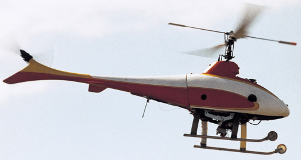
The year was 1987, and a Japanese manufacturer named Yamaha took to the skies with a revolutionary invention: the R-50, the world’s first agricultural drone.

This wasn’t your average drone. It was specifically designed to assist farmers with field analysis and crop mapping. Equipped with a GPS and camera, the R-50 could gather valuable data on crop size, health, and development. This information proved to be a game-changer, allowing farmers to make informed decisions about their crops.
While the R-50 marked a significant milestone, it wasn’t the first drone ever created. Since then, drone technology has advanced rapidly, leading to a wider range of agricultural drones for various purposes. Today’s agricultural drones can be used for tasks like sowing seeds, monitoring crop health, and even spraying crops.
Uses of Drones in Agriculture
Check out this video to learn how you can use drones for agricultural purposes
Here are some applications of drones in agriculture:
1. Transforming Agriculture
The arrival of drones in agriculture has been nothing short of revolutionary. These unmanned aerial vehicles (UAVs) have become essential tools, completely changing how farmers work. Drones offer a wide range of applications that are redefining modern agriculture, with a focus on precision, efficiency, and sustainability.
2. Real-Time Data for Informed Decisions
One of the biggest game-changers is drone-based crop monitoring. Equipped with high-tech cameras and sensors, drones can quickly and precisely scan large fields. This gives farmers valuable information about crop health, soil conditions, and potential problems like pests or diseases. The real-time data allows farmers to make data-driven decisions, such as applying fertilizer only where needed, controlling pests right away, and managing irrigation more effectively. This approach maximizes productivity while minimizing waste.
3. Optimizing Yields
Drones are at the forefront of precision agriculture, a concept that uses technology to optimize crop production and minimize environmental impact. Advanced sensors like multispectral imaging cameras and LiDAR systems can capture intricate details about the soil, like moisture levels and nutrient distribution. This information is used to create detailed field maps, allowing for precision planting. By placing seeds in the ideal location and depth, farmers can maximize yields while using fewer resources.
4. More Than Just Crop Management
Drones are incredibly versatile. They can be used to monitor livestock, conduct search and rescue operations, and even apply pesticides and fertilizers with extreme precision. This targeted approach minimizes chemical use and potential environmental harm, promoting sustainability and saving farmers money.
5. AI and Machine Learning
Artificial intelligence (AI) and machine learning are taking drone data analysis to a whole new level. These technologies allow for predictive analytics, yield forecasting, and even automated decision-making. This means agriculture can become even more precise, optimizing resource use, minimizing environmental impact, and maximizing crop yields worldwide.
As the agricultural industry continues to embrace innovation, drones will likely play an even bigger role. This powerful combination of technology and nature has the potential to ensure food security and promote environmental stewardship for future generations.
The Future of Drones in Agriculture
Watch this video to learn about the future of drone technology
The rise of drones in agriculture is just the beginning. As Drone technology becomes more integrated, the industry can expect exciting advancements alongside some challenges to navigate.
1. Autonomous Flights Powered by AI
One key area of future development is artificial intelligence (AI). Imagine drones that can analyze data and make informed decisions, like identifying specific crop diseases or optimizing flight paths based on weather. Autonomous flight capabilities are another area of promise. Drones programmed for routine tasks like field monitoring or crop spraying could reduce labor costs and boost productivity.
2. Keeping Up with the Rules
As drone use expands, regulations will need to adapt. Privacy, security, and safe airspace integration, especially in high-traffic areas, are all concerns that regulatory bodies will need to address. Collaboration between regulators, industry players, and drone manufacturers will be crucial to developing balanced rules that promote innovation while ensuring safe and responsible use.
3. Addressing Privacy and Safety Concerns
The widespread use of drones near residential areas raises privacy and safety concerns. Clear guidelines, safety protocols, and public education campaigns will be needed to address worries about unauthorized data collection and potential accidents.
4. Integration with Other Technologies
The true magic happens when drones work with other technologies like the Internet of Things (IoT), big data, and precision farming tools. Imagine combining drone data with information from sensors, weather stations, and other sources. This would give farmers a complete picture of their operations, allowing them to make smarter decisions.
This integration could lead to sophisticated decision-support systems that use machine learning and data analysis to optimize yields, reduce costs, and promote sustainability.
5. Further Expansion and New Applications
The current applications of drones in agriculture are just a glimpse of what’s to come. Targeted pest control, seed planting, and even pollination services (to help declining bee populations) are all potential future uses. As drone technology advances, larger and more robust UAVs may be used for tasks like crop harvesting or transporting materials across vast fields.
The possibilities are vast, and the agricultural industry’s continued openness to innovation and adaptation will be crucial in unlocking the full potential of drones in the years to come.
Conclusion
The story of drones in U.S. agriculture is one of remarkable progress. It showcases the industry’s willingness to embrace new technology, transforming how farms operate. This integration of drones into agriculture is a relatively recent development in the history of drones.
From research projects to everyday tools, drones have revolutionized everything from crop monitoring to managing livestock.
High-resolution data from drones has given farmers a bird’s-eye view, enabling them to make smarter decisions. This translates to better yields, lower costs, and more sustainable practices.
Of course, there were challenges. Early on, regulations, costs, and privacy concerns were hurdles to overcome. However farmers persevered, and drone technology kept improving.
The future of farming with Drones looks more promising than ever before.
If you are looking to use drones in farming, learning Drone mapping is the ideal starting point.
Drone U’s mapping course is best-in-class and offers a detailed understanding of how to map using drones in simple and easy-to-understand language.
Check out the Drone mapping course here. The first two lessons are free.


Add Your Comment