Understanding NDVI Mapping, False NDVI and Importance of Radiometrically Calibrated Data….
World population is expected to touch a mammoth 9 billion by 2050. This rise in population means that we have to look for newer and more efficient ways to feed the planet. World Resources Institute estimates a 23% increase in livestock needs between 2006 and 2050. Whereas, beef and mutton requirements will increase by 30%.
This population rise will place greater demands on agriculture. Greater demand for meat will necessitate planting more seeds to feed cattle. There is a need to increase agricultural yields and use resources in the most efficient ways possible. Of course, we have been aggressively addressing this need. According to World Bank, percentage of population employed in agriculture has decreased from 43.28% in 1991 to 26.48% in 2017. Agricultural output has seen a tremendous rise in this same time-frame. This can be attributed to significant technological advances.
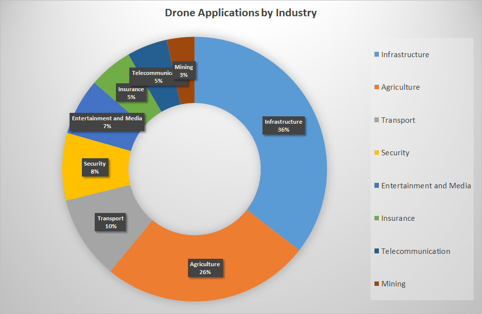
Drones can play a huge role in bringing about more efficient farming practices. Using drones it is possible to implement variable rate technology (which results in the optimum allocation of resources). PWC predicts a market size of 34.2 billion for commercial drone applications in agriculture. This is second only to infrastructure.
In this blog post I discuss NDVI mapping. How do you use NDVI mapping to assess plant health. I also discuss False NDVI and lay out the reasons for absolutely avoiding it. How can you pick the right camera sensor for agricultural drone mapping? What is the importance of using radiometrically calibrated data? These are some of the questions that I dive into. Read on.
How Does NDVI Mapping Work?
NDVI is Normalized Differentiation Vegetation Index.
The human eye sees all plants as green. That does not mean that all wavelengths are being absorbed. Some wavelengths that cannot be seen by the human eye are being reflected. So if you are a UAV pilot taking up NDVI mapping jobs, you need a sensor capable of making this differentiation. You need to determine the precise amount of light that is being reflected (more on this later).
For this, you will have to use a camera that can make this differentiation and hence, weed out the unhealthy plants from the healthy ones. Subsequently you can make actionable insights that will help the farmer allocate his resources in the most efficient way possible. If you use a camera that is not built to understand light, you might end up making wrong recommendations to a farmer.
Folks who use a non-IR cameras offer, what is popularly known as “False NDVI” services. Using a normal camera for assessing plant health is a bad idea. Using False NDVI, you are unable to separate red and near infrared light. This leads to wrong data and incorrect decisions which ultimately proves detrimental to crop health.
Why Ndvi Mapping Is so Useful for Farmers
Let us attempt to understand why NDVI mapping is critical for decision making in agriculture.
NDVI = (NIR – Red) / (NIR + Red)
So, we see all plants as green. However, along with green light, plants also reflect Near Infra-Red light. As you can determine from the above formula, NIR value is directly proportional to NDVI value.
Healthier the plant, higher the NIR value. Vice versa a dead or diseased plant will have a lower NIR value. NDVI value for plants ranges between 0.1 and 1. Non plant surfaces have a high red value and their NDVI falls between 0 and -1.
Using NDVI mapping you can created a color coded map that clearly shows diseased areas. Thus data driven decisions can be made quickly. And wastage of resources can also be avoided
How to Pick the Right Camera Sensor for Agricultural Drone Mapping
Parrot Sequoia and MicaSense RedEdge-M manufacture sensors that are purpose built for agricultural applications.
The Parrot Sequoia+ comes with a sunshine sensor as well as a multi spectral sensor. Because the amount of reflected light from crops tends to vary quite a bit, mapping results are prone to distortion. To address this potential issue, a sunshine sensor is fitted on top of the drone. This sensor records sunlight in the same spectral bands as the multispectral sensor.
The multispectral sensor mounted on the bottom of the drone in four spectral bands – red, green, the red edge and near infrared.
When using a drone for agricultural applications, it is imperative that your camera is radiometrically calibrated. This permits you to make empirical judgements that can benefit the farmer. Why is this necessary?
Your drone camera measures “at sensor irradiance”. While the camera output is in the form of a Digital number or DN. In most cameras, mapping of irradiance to DN is not known. And this mapping or correlation tends to change with change in camera settings. Radiometric calibration should be performed for each band, for different camera settings and optics. It is critical that this mapping is utilized while performing vegetation indexation. If you do not use radiometrically calibrated data, you will end up supplying data which is computed off raw DN’s – inaccurate data with disastrous consequences.
Should You Use a Fixed Wing Drone for Agricultural Mapping?
You might need a fixed wing drone for agricultural mapping if you wish to cover larger tracts of land. A fixed wing drone can fly at greater speed. But you need to be careful while making this transition.
The faster you fly, the more you will have to spend on your drone camera. Flying at higher speed means that you need a camera with a fast shutter speed. Avoid using ND filters at high speed – this will result in blurry images. If you attempt to stitch together images with a high amount of blur, you will end up with a shoddy product.
Conclusion
You need to thoroughly understand the nuances of agricultural drone mapping before venturing into this field. Do not attempt to offer “False NDVI” mapping services. This is just a recipe for disaster. And ensure that you are equipped with the right drone and camera before you think of taking up agricultural jobs. If you plan on taking up larger jobs, it is better to opt for a fixed wing plane with a high end camera. Through drone agricultural mapping, you can, in your own little way help bring about food security.
Check out our Medium page for more such content
Do not forget to subscribe and Listen to Ask Drone U, the #1 drone podcast
Connect with a vibrant drone community by becoming a Drone U member


Add Your Comment